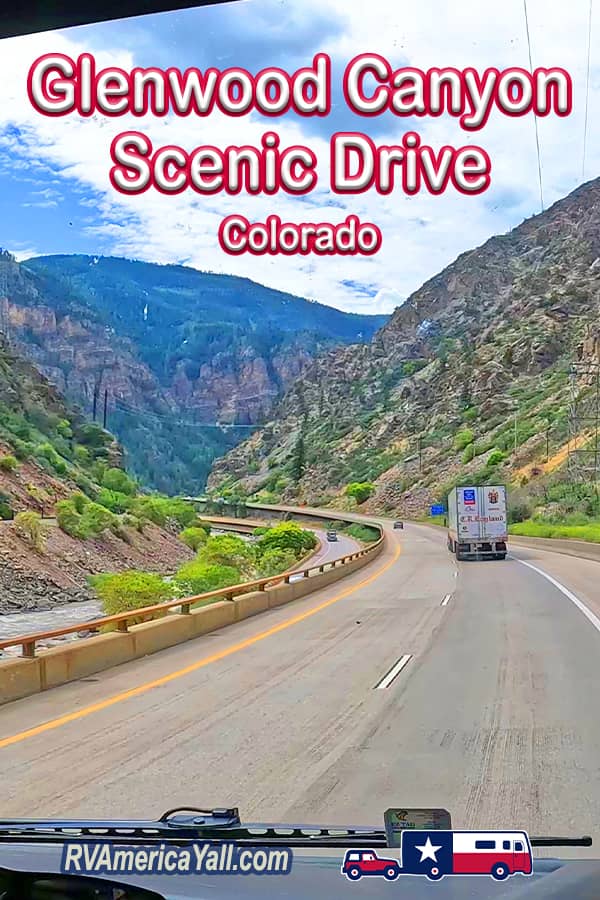
It's not often that we stumble across a must-do scenic drive by accident, but it's not every day that we drive Interstate 70 in Western Colorado. A drive through Glenwood Canyon is an amazing experience that had us saying WOW around every corner.
In this week's video, we drive Interstate 70 on our way from Breckenridge and Frisco CO, headed to Glenwood Springs, Colorado. While we saw a ton of amazing scenery during our drives in Colorado, we had no idea that the travel day would take us along one of the most stunning and amazing scenic drives in the United States just east of Glenwood Springs. We just had to pick up the camera and share it with you... buggy windshield and all!
What Makes the Glenwood Canyon Scenic Drive Unique?
Officially called the Glenwood Canyon Highway, this section of I-70 is unique for a lot of reasons. This 12.5 mile stretch of interstate is the VERY LAST piece built in the original US Interstate highway system. It was completed in 1992.
The Glenwood Canyon Scenic Drive includes 3 tunnels. The Hanging Lake Tunnel is a true original. Each of the east and west bound Hanging Lake Tunnels is 4,000 feet long. They are joined by a garage that houses maintenance, emergency and traffic management facilities. The first of its kind traffic control system features sensors and closed-circuit televisions that are monitored 24 hours a day from the offices within the tunnel. In the case of an emergency, accident, or breakdown in the canyon, emergency vehicles and tow trucks can respond from this garage right away.
Hanging Lake is also home to one of the 4 rest stops that were added to this route when the interstate was constructed. The rest stops offer parking areas for recreation including hiking trails, raft and kayak put ins for the Colorado River, fishing access, restrooms and exhibits.
Also added during construction of the Glenwood Canyon Highway: a paved bike path that runs the entire length of this scenic drive.

A Short History of Glenwood Canyon Highway
So how and why did this engineering marvel come to be?
Like so many of our highways, today's I-70 follows a Ute Indian trail. The Ute people followed the animals through the canyon and the animals took the easiest route. But it took a long time for this section of interstate to come into existence. And building it was no easy task.
According to the Federal Highway Administration, Glenwood Canyon is 3,000 feet deep. Reports we've seen list the canyon walls near the highway at somewhere between 1,300 and 2,000 feet above the river. Speaking of rivers, Glenwood Canyon was carved by the power of the Colorado River 70 Million years ago. This is the largest canyon on the upper portion of the Colorado River.
The canyon stretches through the White River National Forest in the rugged Rocky Mountains. Wildlife viewing opportunities along the scenic route include bighorn sheep, elk, deer, bears, mountain lions and otters.
In 1887 the railroad came through with narrow gauge track. But it would still be a while before cars could pass through the canyon.
State Senator and US Congressman Edward Taylor (who owned a home in Glenwood Springs) founded the Good Roads Movement during the 19th century to obtain funding and planning of roads in Colorado. In 1899 construction of the Taylor State Road to connect Eastern Colorado with Western Colorado began. That road went through Glenwood Canyon. It was a one-lane, dirt road completed in 1902. Taylor State Road was the first automobile route passing through the Colorado Rockies.
Despite the fact that it was heavily impacted by weather with mud and rock slides, Taylor State Road would go on to become a major US transportation artery named Highway 6. US Highway 6 was a 2 lane paved highway built in the 1930s to replace the original road.
As the nation's interstate system was being built, the plans for Interstate 70 coming west originally ended in Denver, so as not to have to build an interstate highway through the Rocky Mountains. In 1958, planners decided that the current Highway 6 through Glenwood Canyon would make sense as a path to stretch I-70 across Colorado. But that was a LOT easier said than done!
Locals were worried that interstate construction would harm the canyon and disrupt the wildlife. A committee of citizens was formed in the 1970s to participate in the planning of the Glenwood Canyon Highway and provide feedback to the engineers and construction team.
Engineers worked to design a highway that would blend in to the environment and protect the wildlife and plants. Construction of the modern interstate began in 1980. The highway was built in tiers to ensure that all 4 lanes could mostly fit into the area already occupied by the 2 lanes of the old Highway 6.
As you watch this video, note that we are traveling Westbound. To the left, you'll sometimes see the Eastbound lanes and they are often higher or lower than our lanes. That's part of the tier system that we mentioned.
You might also catch a glimpse of the Colorado River, the train tracks and the bike path. Imagine the spectacular views from the passenger train or bicycle!
A Train Runs Through It
Trains have been traveling through Glenwood Canyon since 1887. The Denver and Rio Grande Western Railroad traveled this route. The line later became part of the Central Corridor of the Union Pacific Railroad traveling between Denver and Grand Junction. While in Glenwood Springs, we saw an Amtrak train come through to pick up passengers heading East to Chicago onboard the California Zephyr. We might just have to make that trip one of these days. The views on that route would be incredible!
Glenwood Canyon Highway by the Numbers
- The final design of Glenwood Canyon Highway includes sections of bridges and viaducts over 6 miles long.
- There are 3 tunnels, 40+ bridges, 15 miles of retaining walls, 300,000 tons of structural steel, and 1.62 billion pounds of concrete.
- 500 highway workers worked on the project every day. And the final Cost of the project totaled over $490 Million.
But the end of construction wasn't the end of the project. After the build was complete, teams planted seeds and cuttings of native plants that had been stored in plant nurseries built for this project. In all, they planted more than 150,000 native plants in the canyon corridor.
After 12 years, the 12.5 mile Glenwood Canyon Highway opened in 1992. It is the final stretch of the original US interstate system to be built. The project was named an Outstanding Civil Engineering Achievement. And part of the drive has also been named an Historic District.

Tips for Driving Glenwood Canyon Highway
Just as the original road was susceptible to weather, today, this scenic byway closes due to flash flood risk, rock slides, wildfires or snow. The Grizzly Creek Fire burned in the area for 4 months in 2020. This stretch of highway was closed for 2 weeks as a result of that fire. Always check the weather reports and road conditions before you set out on a road trip through Glenwood Canyon.
There are signs monitoring your speed throughout the canyon. It's easy to get distracted by the amazing views, but wildlife could cross the road in some places. Remember to watch the speed limit, relax and enjoy the scenery.
Where is Glenwood Canyon Scenic Drive?
📍 Glenwood Canyon Highway runs along the Colorado River between Dotsero, Colorado and Glenwood Springs, Colorado on US Interstate 70. It is west of the Continental Divide.
Rest Areas in Glenwood Canyon
Today's highway includes 4 rest areas, each with a parking area, restrooms and access to recreational activities like hiking trails, biking trails, a boat ramp for rafts and kayaks, and fishing. We can't imagine a more scenic rest area. If you're just driving through or on a long travel day, one of these rest areas might be a nice place to take a break and stretch your legs with a short walk. And if you're looking for a parking lot for your car while you participate in outdoor adventures, you've got 4 options within the 12 mile scenic drive.
From East to West they are:
- Bair Ranch Rest Area
- Hanging Lake Rest Area
- Grizzly Creek Rest Area
- No Name Rest Area
There are large signs along the highway alerting you when one of these rest stops is approaching.
We didn't stop at one of the rest areas. Looking at them on Google Maps, some have larger parking areas than others. If you drive a larger rig, you may want to take a look and plan your stop ahead of time.
Glenwood Canyon Bike Path
As mentioned, a fully paved bicycle / pedestrian path runs through Glenwood Canyon and is often viewable from the highway. This path is also known as the Glenwood Canyon Recreation Path or Glenwood Canyon Trail. Bike trail website MTB Project rates the path as "Easy" and lists the elevations on the path as ranging from 5,795 to 6,149 feet above sea level with a maximum grade of 7%.

Get More Information on the Glenwood Canyon Scenic Road
General Information and Updates: Colorado Department of Transportation
Travel Alerts and Road Condition Updates: COTrip
For More on the Building of Glenwood Canyon Highway
Watch Colorado Experience: The Glenwood Canyon Highway from Rocky Mountain PBS
Glenwood Canyon Scenic Drive Fun Facts
Years Constructed
1980 - 1992
Construction Time / Years
12 Years
Length
12.5 Miles
One of the Most Scenic
Stretches of US Interstate
Open Year Round?
Weather Dependent
Vehicle Size Restrictions
RVs and 18-Wheel Trucks OK
Wrapping It All Up
Our drive through Glenwood Canyon was an unexpected surprise, and one we will never forget!
For Another Scenic Drive in Colorado, check out incredible Trail Ridge Road which is in amazing Rocky Mountain National Park!
Our next stop is the Glenwood Springs area! We can't wait to explore the historic downtown area and more.